
 For 20 years, I’ve been driving back and forth from my home on the Oregon coast to San Jose, California, where my family lives. I usually take I-5, a straight shot inland, or, if there’s snow in the mountains, I take Highway 101 along the coast. See the same things, stop at the same places, no time for side trips, tempting as they are. It takes me about 13 hours.
This time was different. I scheduled in extra time for a vacation. Just outside Eugene, I left I-5 and headed southeast on Oregon Highway 58. I wanted to see some of the sights I’d seen in the winter on the train and take a little time for myself. I wanted to see waterfalls and lakes. I wanted to hike in the high country. I wanted to sit by a river and write poetry. I wanted to see the tiny towns along the way and end up in Klamath Falls where my grandmother started her teaching career a little over a hundred years ago. So I did.
Everything published about Highway 58 emphasizes that it leads to Crater Lake, and yes, you can get there that way, but I had already seen Crater Lake several times. I was seeking new territory. Over the next few posts, I plan to share some of that country with you. Did it bother me to be a woman traveling alone? Maybe it should have, but no. I enjoyed my freedom.
Things didn’t start off great as I left home on Labor Day. It killed me to leave Annie, who is not a good traveler. Assuring her she’d have a great time with her dog sitter, “Auntie Jo,” did not keep her from following me around with her tail hanging low. Then I discovered the restaurant where I had my heart set on eating lunch–Eats & Treats in Philomath, so good–is not open on Mondays. So I forged on, taking a different route to Eugene, only to get miserably lost. Thank God for GPS. I ended up eating lunch at the kind of diner where they vacuum around your feet while the waitress hollers, “Whatcha gonna have?” The chicken tortilla soup with two chunks of chicken and four tortilla squares floating on top set my stomach on fire.
 But then I got out of the city and encountered the first of two covered bridges on this route. The Lowell Covered Bridge is located at the Dexter Reservoir. Ah! Water, trees, blue sky. Also a restroom. I took pictures of the bridge and sank onto a bench to stare at the lake. Now we were on vacation.
Down the road, I came to the Office Bridge. It has openings for both cars and pedestrians. Walk or drive through into a big park with covered picnic areas and hiking trails. I could have sat there and stared at the Willamette River flowing below forever. Note that the directions I got online were wrong. I kept looking for West Road. I think it was a typo. Simply take the Westfir exit off 58 and follow the signs for three miles. There’s a store and a resort there for those who want to stay a while.
 Having gotten a late start and gotten lost a couple times, I hadn’t really gotten far from Eugene, but that wasn’t the point. I spent the night in Oakridge, population 3,200. I toured the “downtown business district.” It was pretty quiet on the holiday. Everything was coated in dust from months of no rain. Relaxing at the Best Western (yes, they have one), I noticed the phone book: six yellow pages for business, 32 pages total. The phone book is published by the local newspaper, the Dead Mountain Echo, not a bad local weekly. Why would anybody stay here, I thought. But I learned it’s a hub for mountain bikers, of which there were plenty, and folks also make beer there. They even have a Keg and Cask festival in August. Being only two hours from Eugene if you don’t mess around, Oakridge has a small-town feel with access to big-city amenities.
At dinnertime, I was surprised to find a Mazatlan Mexican restaurant in town and even more surprised that the food was fabulous. Shame on me for stereotyping small towns.
In the morning, surprise! It was raining. What? I had all these hiking plans and this list of stops: hot spring, waterfalls, trails, lakes. Rain? The guy at the gas station was deliriously happy to see water coming out of the sky and hoped for lots more. Sure, but today? I get plenty of rain at home. Never mind, we Oregonians carry on.
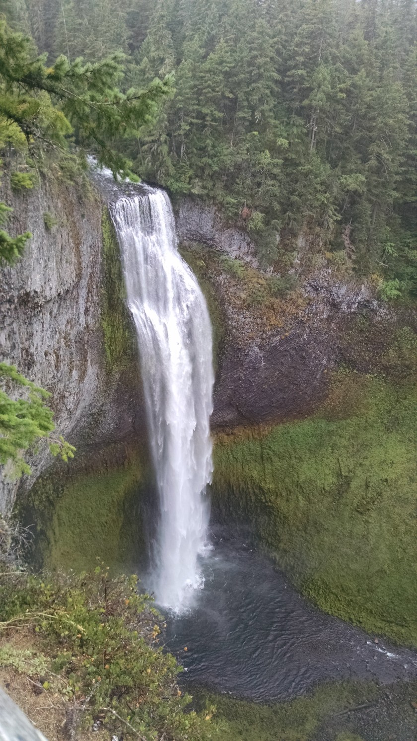
Somehow I missed the McCreadie Hot Springs–darned online directions again–but I found the biggest waterfall. Cascading 286 feet, Salt Creek Falls is the second highest waterfall in Oregon, Multnomah being the highest. It was worth the wet walk. Oh my gosh. The trail took me along the creek until it suddenly fell off a ledge and there were the falls, so big, so white, falling deep into a canyon below. My camera can’t portray the way it made me feel. Deep breath.
From the waterfall, I started off on one of the many trails, but it was just too wet, and I feared I would slip and fall into the creek. Nobody knew where I was. Bad idea. Back on the road. Waldo Lake, Diamond Peak, the Willamette Pass Ski Resort, Crescent Lake, Odell Lake, the turnoff to Crater Lake, and finally Klamath Falls, where I pigged out on a Reuben sandwich at Elmer’s and checked into the Holiday Inn Express. Back in civilization again. But that’s another story. If you’re in the mood to wander, check out Highway 58. There are lots of trains, more waterfalls to see, campgrounds and picnic areas, and places to ski. (Bring chains in the winter.The Willamette Pass is over 5,000 feet.)
BTW, I hear truckers take it south to California because it’s faster than I-5. Not the way I did it.
